A short history
The Netherlands is situated in the delta where the rivers the Scheldt, the Rhine, the Meuse and the Yssel find their way to the Northsea. A large part of the coastal area was characterised by tidal mud flats that were exposed to the uncontrolled flow of rivers. The hostile environment did not withhold people to settle. Nontheless the impenetrable region remained beyond the northern frontier of the Roman empire.
The Zuyder Sea (Zuiderzee or Southern Sea) was formed by a series of serious flood events in the early middle ages. The floodings caused a permanent open connection between the North Sea and lake Almere (or lake Flevo as the Romans called it). The name Zuyder Sea was first mentioned in the year 1340 and the body of water would grow to a surface of approximately 5,900 km² with a few islands in it.
The unhindered access to the Northsea attracted settlements. The settlements were exposed to the tides and this called for dike constructions. Land reclamation began in the 14th century, not only in order to gain agricultural land but more importantly to minimize the overall length of fragile sea dikes that protected the existing land. This in turn caused some towns to lose their advantage of direct access to water, a phenomenon that we see again later on in the Zuyder Sea history.
Land reclamation was done by building dikes around a stretch of water and pumping the water out by windmills. The new gained land is below sea level. Permanent water management is needed in order to keep the land dry and/or moist enough.
During the years there are villages lost into the sea. After land reclamation the foundation of an old castle reappeared near Kuinre. Some long-lost villages (like historic Nagele and Marknesse) are only located as recent as in 2020. Others (like a castle near Nijkerk) are yet to be found.
For the whole area around the Zuyder Sea trade flourished because of the access to the Northsea. At first trade was orientated to the Baltics (Eastern Sea). The Hanseatic-league dominated the Baltic maritime trade from the 1100s and Hansa merchant guilds and market towns emerged everywhere around the Zuyder Sea as well.
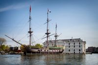
By the 16th century Northsea herring fishery and trade with Asia and Africa as well as the Americas became more important. In these years he biggest of sailing vessels crossed the Zuyder Sea. Of course these years are also responsible for very dark pages in Dutch history because of the slave trade and the exploitation of the oversea colonies. In the 17th and 18th century whale fishing in the northern arctic became in demand too.
All around the Zuyder Sea many and big shipyards emerged as a result of these nautical activities.
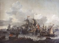
Sailing the Zuyder Sea was not without danger. From the 14th century and possible earlier visual markers, like buoys, barrels and stakes were deployed for safety (and to collect toll). Intense traffic, sea battles, the sometimes shallow depth, strong tide currents and the dependency of shifting wind, made these waters rich in shipwrecks, even by international standards. Remarkable are the treacherous short length compared with the hight of the waves.
In 1876 the Noordzeekanaal – a channel between Amsterdam and IJmuiden – was completed and this was a convenient short cut to the Northsea for lager trade ships.
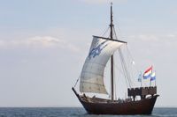
From the beginning of the 19th century fishery gained importance, culminating in an estimated fleet of 3,000 small wooden sailing vessels around the year 1900. A popular fishing vessel type was the flatboat with shallow draft, that was ideal for the Zuyder Sea with a depth ranging from a 8 meter or so to just a couple of decimetre. Typical fishing vessels are known as Aak, Botter and Schokker. The Tjalk was popular as a freighter.
Despite the open connection to the Northsea in the north, the southern part of the Zuyder Sea long remained under influence of the sweet water supply of rivers. Until the 16th century it was possible to fish for pike and bream. Migratory species such as sturgeon and salmon became at the end of the middle ages an important source of income. I took until the 17th century for a complete salinization of the southern part of the Zuyder Sea. From then on herring, anchovies and flounder gained importance.
The Zuyder Sea not only offered fish, but also eel, shrimps, mussels, sea snails and sea weed.
It was from 1882 that every fishing vessels had to display an unique registration code that reveiled the home port. You can see these registration numbers often very clearly on old pictures. It is not only the vessel numbers on these old pictures that distinguises the fishery towns from eachother. Different characteristic traditional costumes does too. Wearing traditional costumes died out in the 1980’s in most of the towns together with the old generations.
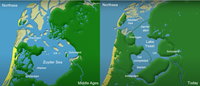
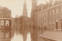
Securing the hinterland from tides and flooding always remained a concern. A major flooding in 1916 pushed the idea to close off the Zuyder Sea. Access to the open sea came to an end in 1932 with the closing of a long barrier dam, known as the Afsluitdijk. Plans to do so stem from the second half of the 1800s and the more the plans became real, the less was invested in this sort of small scale fishery industry. The Zuyder Sea was no competition for the upcoming Northsea trawler fishery eighter.
(71B15B060206FBD374E2E27FD046A803).jpg/picture-200?_=178a7c26fe8)
After completion of the barrier dam the Zuyder Sea was renamed as Lake Yssel (IJsselmeer). Salt water became fresh and for large parts water became land. The water had to make way for new large scale farmland. This had a dramatic effect on the livelihood of the people and as a consequence the visual aids to navigation. Old lights lost their function, while new lights emerged elsewhere.
On this website we present a selection of the lights in this region that could have been seen throughout the history of the Zuyder Sea.