NET-AAH IJsselmonding (Estuary river Yssel)
Town Kampen
Location North-West of Kampen
Position Lat (dms) 52°34’59” N
Position Long (dms) 5°46’40” E
QTH-locator JO22VN
Year built -
Material -
Height construction (m) -
Height light (m) -
Range light (mi) -
Characterisic -
Additional information:
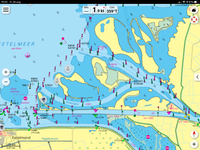
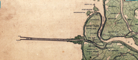
The location (locally known as Ketel Diep or Ketelmeer) consists of a shipping lane protected by two long breakwater dams with a length of more than 3 km. The dams go back to 1826, including a light on the southern pier head.
From around 1900 two (white) lights where added at the northern bank at the landside of the dams (known as Keteleiland). In the 1930s the pier heads are outfitted with red and green lights. Apart from some minor changes, this is the situation up until today.
The former fishing fleet of Kampen and IJsselmuiden, that had to pass the lights, can be recognized by KP and IJS as vessel registration.
Last updated: August 2020