NET-AAM Monnickendam*
Town Monnickendam
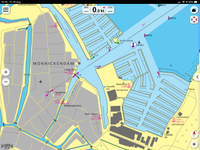
Location Monnickendam old harbour
Position Lat (dms) 52°27’39” N
Position Long (dms) 5°02’17” E
QTH-locator JO22ML
Year built -
Material -
Height construction (m) -
Height light (m) -
Range light (mi) -
Characterisic -
*Note August 2020: Needs more research for an ARLHS-application.
Additional information:
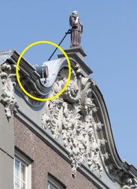
There is an indication that both the old city hall and old city tower had been used as a lighthouse in the 16th century. On maps the town has a harbour-light at the waterfront near the draw bridge at least since 1892.
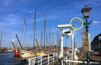
Today modern harbour lights red and green are placed at the old pier heads. A red rear high is placed in town to mark an approach line in combination with another red light as a front low (on the bridge) and with non-illuminating buoys.
The fishing fleet of Monnickendam can be recognized by MO as vessel registration.
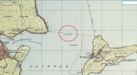
On maps from 1850 onwards another light is situated in the sea halfway between Katwoude and Marken Island, first on a dam, later the dam disappears while the light remains until the late 1950s. The spot is locally known as the Reiger.
Last updated: August 2020