NET-AAR Urk Harbour
Town Urk
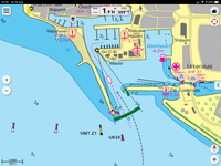
Location Urk harbour
Position Lat (dms) 52°39’23” N
Position Long (dms) 5°35’52” E
QTH-locator JO22TP
Year built -
Material -
Height construction (m)
Height light (m) -
Range light (mi) -
Characterisic -
Additional information:
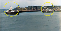
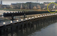
Former Urk island has NET-026, but the town has a fishing community too. At least since 1911 the harbour has lights on the two pier heads. By 1955 the harbour is substantial extended, so are the pier heads and thus the harbour-lights, although one more than the other. For the new harbour entrance a third light is needed. The three lights work together for approach. Today the most front pierhead has a replica of the old light. The former fishing fleet of Urk can be recognized by UK as vessel registration.
Last updated: August 2020